About the Hike: Strenuous hike with plenty of hiking in thinner air. Upper elevations are cool even in summer, though spring may require snow gear. Don't attempt the hike without proper training. Very similiar to San Jacinto.
Time: Start: 10.20am, End: 8pm, total hiking time = 9hrs 40min
Distance: 15.7mi round-trip, elevation gain: from 5500ft to 10600ft
Driving and other Info:
Follow I-15N to 215N to 10E, take the 38E highway to the Mill Creek Ranger Station. Trailhead is behind the fire station at Angelus Oaks. 126mi, 2hrs 11min from La Jolla.
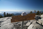
Our Hike: Temperatures were soaring on the day we hiked this trail. The lower elevations are hotter, but also have plenty of shade, so the biggest problem in summer is bugs. This trail would be best in fall. Steep ascents for about 2 mi, then flatter to Manzanita Springs, followed by steep ascents again to Limber Pine and beyond. There are 3 peaks: San Bernardino peak, East San Bernardino peak and Anderson peak (also confusingly called San Bernardino Mountain). Our goal was to get to San Bernardino peak. Map for all peak locations. Preparation is key, just as with San Jacinto, i.e. good sleep, light lunch, small snacks and water along the way, ascending gradually after 9000ft. Once acclimatized, one can push oneself.
Sunday, June 22, 2008
San Jacinto
 About the Hike: Strenuous hike with plenty of hiking in thinner air. Generally cool in summer and fall, though spring may require snow gear. Don't attempt the hike without proper training.
Time: Start: 8.45am, End: 8pm, total hiking time = 11hrs 15min
Distance: 17mi roudtrip, elevation gain: from 6280ft to 10804ft
Driving and other Info:
Follow I-15N to 79S, left at 371, left at 74 and right at 243 to Idyllwild, the ranger station is on Pine Crest Ave. Follow Pine Crest and Fern Valley to the end to the top of Humber Park, which is the trailhead.
Our Hike: We did this hike twice. First time was faster, around 7.5hrs. Second time was slower, around 11hrs, mainly due to additional weight and lack of sleep the previous day. We learnt some important lessons on the hike: sleep well before, have a light lunch during the hike and climb gradually after 8000ft. The views are fantastic, but you won't enjoy it if you feel the effects of altitude, so prepare well. The path goes steep-flat-steep, so the last section to the peak is the toughest. The path is rocky and has tree roots cutting across, so watch your step.
Dripping Springs
 About the Hike: Strenuous hike, mainly due to distance covered, elevation gain is not very taxing. Summers are too hot, preferred time is spring or fall. Vegetation coverage is limited initially, but gets more and more wooded later. It would be useful to wear protective (long sleeve) clothing or have a machete to prevent getting scratches from thorns / plants that grow into the trail frequently. Also WATCH OUT for rattlesnakes ! They are well-camouflages, and sometimes may be on the trail.
Time: Start: 10.30am, End: 6.45pm, total hiking time = 7hr 45min (lunch 30min)
Distance: 6.8mi one-way on trail, 0.4mi along campground, total = 14.4mi, elevation: 1600ft to 4400ft variation
Driving and other Info:
1 hr (64mi) from La Jolla, http://backpacker.trimbleoutdoors.com/viewTrip.aspx?tripID=8492&mode=TripMap
http://www.etreking.com/eTreking/Pages/SanDiego.html
Our Hike: We started a little late in the morning, but were confident of finishing before sunset. The trailhead starts at a campground and we approached it going on 78E. There is a sign for "Dripping Springs" opposite the campground and trail. Contour maps help understand the trail's up and downs, so we armed ourselves with a digital pic of the trail map. We also had the map from the link above, which was surprisingly easy to follow.
Lunchbreak was around 2.30pm, and we had covered about 6mi, unsure of whether to continue or not. I think the lunch energized us enough to complete the hike, so we went till the trail ended at the Palomar McGee trail. The way back was rather eventful, we saw two snakes, includinga southwestern speckled rattlesnake, which was so well camouflaged, I didn't see it till I almost stepped on it on the trail. After that, our pace slowed a little, as we scrutinized shaded trail areas closely for snakes. We were back at the trailhead by 6.45pm.
Subscribe to:
Posts (Atom)